|
A video explaining the basics of laser scanning and it's benefits.
What is High Definition Laser Scanning?
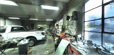
High Definition Laser Scanning uses a digital surveying unit to capture "points" of an existing building or site to produce a three dimensional, highly accurate representation of the real world conditions. The unit will scan millions or points (or more!) on a single scan session, and will be combined to form a "pointcloud" of the existing conditions. Where is that door on the exterior face of the building? What diameter is that pipe in the mechanical room? With laser scanning, we can tell within thousands of an inch. This produces an existing conditions survey far more accurate than a field crew measuring with a tape measure and transferring that to notes on graph paper. And on top of that, it continually takes pictures that can be stitched together to give a picture like feel to the pointcloud like this: Is this a picture or is this a scan?
|
Why use High Definition Laser Scanning?
- Accurate measurements and site location based on real world coordinates, far better than conventional measurement practices with a measuring tape and notepad. - The scan will give you every minute detail of the existing field conditions. Not just the location of the pipe, but the size of every fitting and valve. Every brick joint will have an accurate height. - Reduction of measurement errors and return visits for additional field measurements to verify important items missed the first time. - Provides the owner with data that can be used by architects, engineers and land surveyors reducing number of field visits and therefore project design costs. - Can be used to produce conventional property surveys and topographical surveys often required by planning and zoning departments. Do you have an existing building and want to construct a new addition or have a renovation in mind? Using the latest laser scanning technology, we are able to produce highly accurate existing conditions modeling, reducing the errors commonly made through the tape measure and paper field measure up method.
|
